
Updated 2/2014 with new watch (Globalsat GH-625XT), successor to the originally portrayed GH-625m (pictures).
|
Quick Facts:
* Each time the watch logs its position this creates one track point. Depending on the recording interval, you can record 33 hours (one second intervals) or much more. |
Introduction
In summer 2009 I started taking a GPS-watch on all my flights. First I used a GlobalSat GH-625m, later I upgraded to its successor, the GlobalSat GH-625XT, which I am still using now. The GH-625XT offers all the same functions and the same user interface, but way more memory capacity and double the battery life of its predecessor. These watches are basically designed for running and other outdoor sports. Its main competitors are the Forerunner watches of Garmin. However, these are a bit more fixed on sports and therefore might not provide as many functions when used for flying. I need to stress though, that the Garmin watches are far more popular and that they seem a bit more mature. The GlobalSat watches still have some minor errors and glitches. However, the tech team is constantly working on the watches and frequently releases software updates. In addition, they're very open to ideas and suggestions by customers.
First off: Overall I'm very happy with my watch. I've been using it for five years now, and it did very well on all my flights despite definitely not being designed for that.
Using GPS on an airplane
Generally, using a GPS on a plane should do no harm to the plane or the security on board, since the GPS device does only receive data and not send anything itself. Because it doesn't send, it has no way of interfering with instruments in the cockpit. Secondly, GPS is also used up front in cockpits, so it is a save and common technology used in aviation every day
I know many airline pilots who use their own GPS device in the cockpit or allow passengers they know to place theirs in the cockpit. However, some airlines prohibit GPS on board of their planes. So to be sure, inform yourself first before flying.
I can not be held responsible for anything having to do with using a GPS device on an airplane, may it be damage to the device itself, it being taken away, or any charges of airlines for usage on board!
Reasons to use a GPS watch
Nowadays there are numerous devices which can record GPS data (so-called GPS loggers), and they come in all shapes, starting from the size of a USB stick all the way up to proper GPS hardware known from the automobile world. Even most mobile phones provide GPS functionality and can record GPS tracks using third-party applications.
So what are the benefits of using a GPS watch? First of all, it's comfort. You can just wear it on your arm the whole flight, without looking suspicious to anyone, be it Flight Attendants or passengers in the seats next to you. And you have both hands free to do other stuff, taking pictures for example. Compared to small devices (USB stick size), the watch actually has a display which lets you see most data inflight, which can be a very interesting means of following the progress of your flight. In addition this lets you see live IF and WHAT it is recording, so there will be no surprises about wrongly recorded data later-on. Plus wearing the watch on your arm instead of having a logger somewhere in your pockets dramatically increases the strength of the satellite connection.
Compared to using a mobile phone, the watch's benefits are the longer battery life, that you won't use up all your phone's battery, and that it can be used during takeoffs and landings without attracting attention. When you just start up your phone sometime in flight, it is likely that it won't get a GPS fix at all because of the fast speed you're travelling at. The watch however will have been running the whole flight, always knowing its position and connecting to new satellites if needed. The same downsides of using mobile phones also apply to proper GPS devices. However, these do have the advantage of more sophisticated screens, offering much better data display and more detailed maps than the watch.
Getting a Satellite Fix
In order to be able to know and log its position, the watch needs to have contact to at least 4 satellites. First establishing this contact after a longer downtime (of more than 2-3 hours) can take up to 3-5 minutes and should be performed outside and possibly when standing still. It's best to do this before entering the terminal building (I've done it inside airplanes while at the gate numerous times, and mostly it works too). Thereafter, you can switch the watch off again. When you're seating down on your window seat in the airplane, the watch has no problem finding the satellites again. Most of the time it found way more than the required 4 satellites (see how many are marked black in the photo below!) 
The watch even managed to establish a connection when I had a window seat, but no window in my row (only in the rows before and after). Even when the persons in these rows closed their window blinds, it didn't really matter to my watch!
Contact seemed to be a bit better on B737 and CRJ planes, and a bit less good on the MD-11 and the A380. The only plane it didn't work was on my single Boeing 787 flight. On a few of my transatlantic flights, the watch lost contact in the middle of the ocean (there aren't too many satellites there), but re-established it again afterwards. As can be seen on the photo above, most satellites are located around the middle of the planet, with not so many up in the far north. That's why it is better to sit on the southern side. However, I still had no problems establishing a connection even from a seat on the northern side of the plane.
Overview of functions
So what can the watch do in addition to saving the position every second?
Working with fix points
The watch can save 100 user-defined points. These can either be entered on the watch directly (a bit tedious) or uploaded from your computer. These points can be used in two interesting ways:
- First you can greate a "go to" to a single point, or create whole routes consisting of multiple points, and observe as you're proceeding. The watch will show the remaining distance and time to the next point. While the distance is always about 5% too high, the calculated time is quite exact.
- Secondly, you can use these points to see where you're flying, as these points are shown on a simple navigation display.
Below are two photos of this: On the very left you see the map mode, which shows us passing "between" Manchester (EGCC) and London (EGLL). On the right it shows the remaining distance to our destination, Amsterdam (EHAM). The photo on the right hand side pictures the "go to"-option. It shows the actual heading, the heading to the next point, as well as the remaining distance and time to get there. As you can see, the time is pretty exact! Note: The dotted lines above EGCC are some kind of error, which only showed up on long flights. However, they're only present on the watch display, not in the log file on your computer. So don't worry! 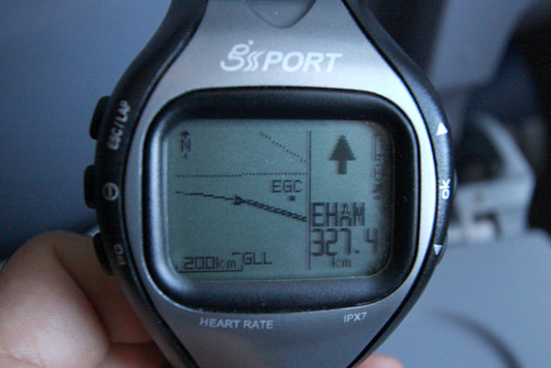

Displaying flight data
The watch can display various flight parameters. You can create four different "pages", and fill them with up to four different data sources each. This can be done directly on the watch. For flying I created a display featuring speed, altitude, vertical speed and remaining distance. Unfortunately, there are still some flaws here: 
First there are the units. Up to now you can choose between metric, statue miles and nautical. Nautical will provide you with distance in nautical miles and speed in knots, but the altitude is also displayed in miles instead of feet. I asked the developers for an aviation mode and I hope they'll include it in the next update.
Speed is displayed pretty accurately. However, at the moment, the display starts from 0 again after passing 655. This only happens on the watch display - the logged speed is correct. I hope this is corrected soon. As you can see on the photo, the measurement is pretty accurate (280 + 655 = 935).
Update: With the GH-625XT, this is fixed and the (roughly) correct speed is displayed.
Altitude: The displayed altitude is always about 500-1'000ft too high. But this isn't really the watch's fault, since measuring altitudes with satellites just isn't that great. But knowing the standard flying altitudes for the regions you're flying in, you can just round the data to this and you should be fine most of the time.
Vertical Speed: I can't really judge the correctness of this one, since up to now it is not available in ft/min. However, it seems that the display is not continuous but only offers certain steps, like -14, -18, -22, etc. This isn't so much of a problem though, since you can easily find out your vertical speed afterwards when looking at the log file on your computer.
Remaining distance: As mentioned above, the distance shown by the watch is always a little too high, even more when considering that the watch goes direct and the plane is bound to airways. However, since the deviation isn't that big and you can always find out how long your trip was afterwards, it's ok.
Data Analysis
Having the watch display some data inflight is admittedly neat, but the most impressive and helpful feature is having all the data of your flights saved, free to watch and analyze on your computer afterwards. The saving of the position is extremely accurate, particularly if the watch is in contact with more than 4 satellites. Just look at the taxiing in Zurich - not too bad, huh? 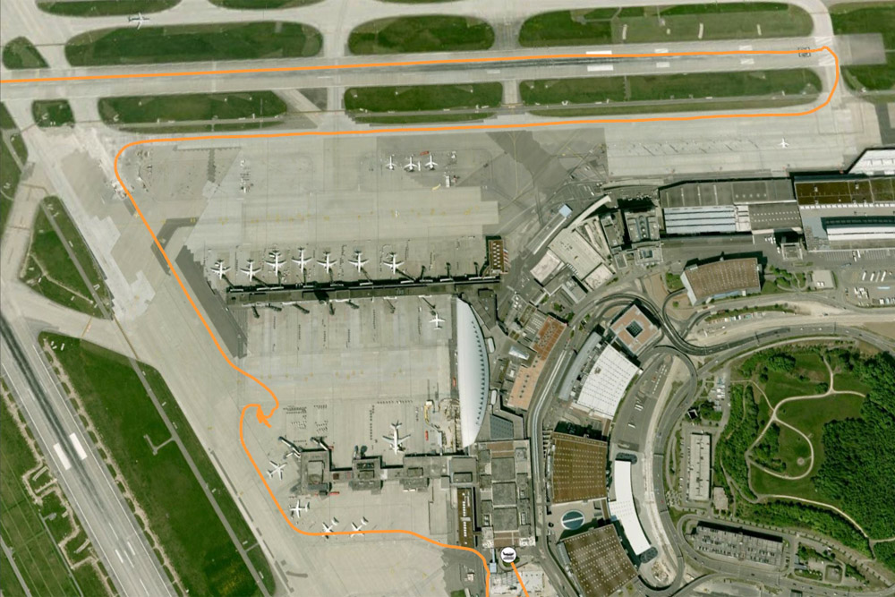
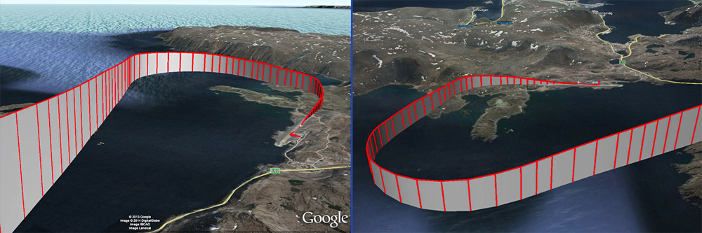
Of course, the data can also be displayed in 3D, for example in Google Earth. This allows you to analyse interesting parts of your flights, like spectacular approaches (for example into Norwegian Honningsvag, ENHV)
You can also process the file with various programs. I usually work with SportTracks 3 by Zone Five Software. This software lets you archive your GPS tracks, but also displays all their data and translates them into maps and graphs. It also lets you export them to various file formats, to be used with other software (like Google Earth) or to upload them online. Here's what I usually use SportTracks for, based on a Bombardier Q400 flight from Guernsey to Southampton: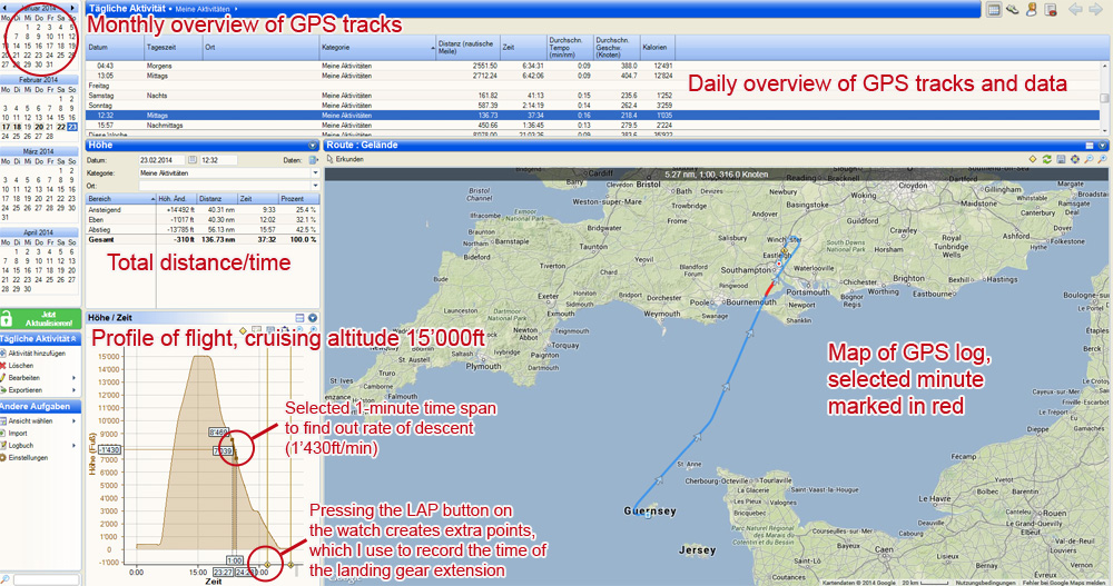
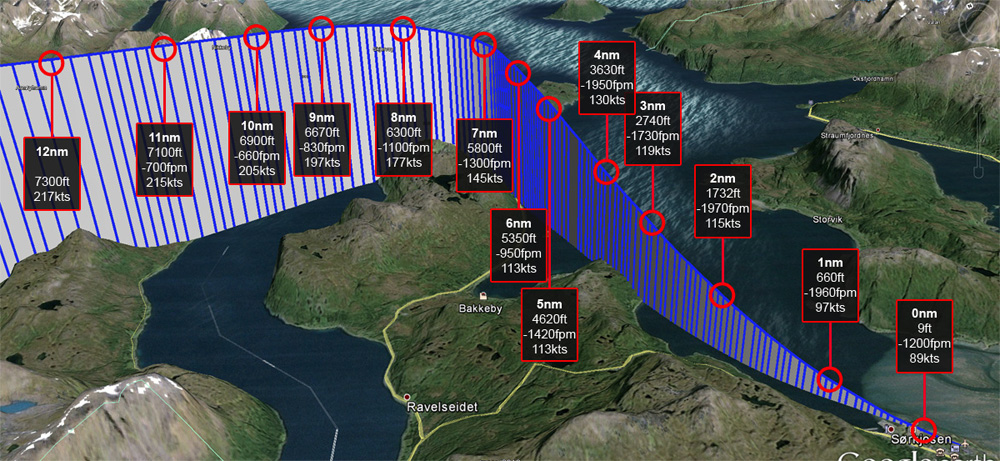
Using this data, Google Earth and a bit of Photoshop, you can create impressive reconstructions of your flight paths. Like this steep approach into Sorkjosen, Norway (ENSR) with pretty impressive sink rates.
Finally, here are some of my flights in Google Maps you can have a look at!
You can keep track of all my GPS flight logs (well over 200 by now) on my Wikiloc Page.
Of course there are many more possibilities of what to do with your GPS data.
The only limiting factor is the battery: Battery life is only about 15 to 20 hours. But it is no problem to recharge the watch even when recording data. Therefore I recommend taking an USB charger or your laptop on your longhaul flights.
All things considered, to me the GPS watch has become an integral part of all flying adventures. Inflight I can use it to see how high we're flying, what time we'll reach the destination, what route we're flying, and what way we are approaching our destination (very valuable for photography!). After the flights, I can use the GPS logs to relive the flight, find interesting objects/scenery I photographed enroute, analyze the pilots' work and create nice maps to be used in online trip reports. And the logs are invaluable souvenirs of each trip that remain accessible forever.
To put it short: I wouldn't want to fly without it anymore!